Ride The Tide - The Course Map And Description

Ride the tide Course Map, Description, Schedule and Logistics.
Full Course Map at bottom - first up schedule and logistics. To download a MS Word Version of this entire packet - Click Here
Thanks for signing up for the first annual Whole Foods Terrapin Crossraods Ride the Tide! Here's what you need know.
Schedule
- 8:00am – First Pre Shuttle from 101 Shop to Fort Baker. This is best way to make a fast exit from the event as your car and board will be at the finish line already! (For Boards and People)
- 9:00am - Last Pre Shuttle from Shop to Fort Baker – See above! (For Boards and People)
- 8:30-9:30am - Breakfast Served at Fort Baker
- 9:45am – Mandatory Skippers Meeting All Participants
- 10:00am – Group Paddle Division Starts (not a social cruise it's an athletic challenge)
- 10:15am – Racing Class Division Start - UPDATED!
- 12:00-1:30 – First Arrivers at Shop
- 12:30-2:30pm – Lunch
- 2:00pm – First Shuttle Back To Fort Baker (For Boards and People)
- 3:00pm – Second Shuttle Back to Fort Baker (For Boards and People)
- 4:00pm – Final Shuttle Back to Fort Baker (For Boards and People)
What to bring/wear/safety first
- On the water hydration is key. Small Powerbar/Cliff Bar/Gu for a quick snack.
- NO NATURAL FIBERS in your apparel. A 2mm wetsuit is ideal and recommended.
- A Coast Guard Approved PFD. We are requiring you to wear the jacket. Inflatable PFD's are fine
- A cell phone in a water proof bag is a good idea.
- On the water support boat VHF RADIO – Chanel 69. By Cell 415-606-5078.
- The Coast Guard Phone number is 415-331-8247 or 911.
- A leash is required and must be worn.
- A hat & sunscreen. This a lot of sun time.
- Find someone paddling the same speed and stick together.
- Learn Proper Knee Paddling. Choke up on the paddle. Click Here For Video Instructions
- Check in and Check Out with the registration teams.
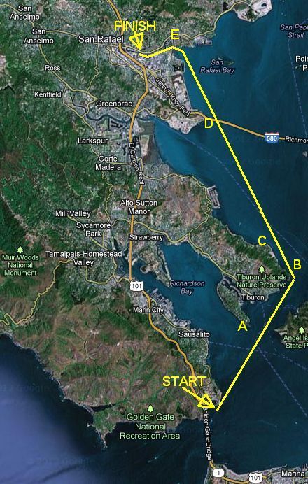
THE COURSE
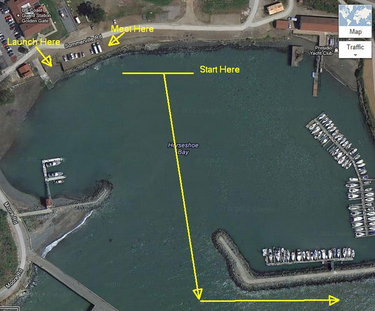
Starting Area - Horseshoe Cove Sausalito, Aka Fort Baker, Aka Cavallo Point (pictured at top). Stay inside the cove. We will be meeting in the middle of the cove. There is a ramp to access the water. Booties or water shoe are not a bad idea. We will have a loose group format start. As you exit the cove stay make a sharp left. A Golden Gate Ferry Route runs from SF to Sausalito so be on the lookout left to right .Turn hard left as you exit and head straight for point A
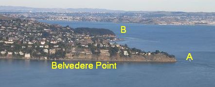
Point A – Belvedere Point. A large Green Buoy sits 300ft off shore. Water right near the buoy can be rough so pass by it with the buoy on your left. Racers may want to pass on the right as some legit surf may be had here. You are however also crossing two Yacht clubs along the way here (Corinthian and San Francisco) so be on the lookout for increased small boat traffic. Ferries also come in from San Francisco and Angel Island here. If for any reason you need and emergency exit point this is a good place – Tiburon. This area is known as Racoon Straights after the HMS Racoon. Head for Point B.
Point B - Keil Cove. There are some submerged rocks close to shore at the point so stay at least 15-20ft away from the point. Then after making a sharp 90 degree left turn, it's a great first spot to get some rest, hydration, and perhaps a snack.
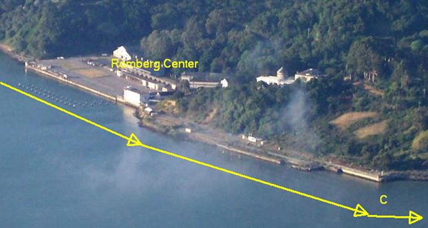
Point C – Romberg Center aka California City. Start making leftward progress in your paddling line as you head for point D. Look for the start of XXXXX pattern in the Richmond Bridge structures left hand (Marin) side. This is the spot where the two parallel roadways meet and then become a double decker structure. San Quentin Prison will be visible to your left.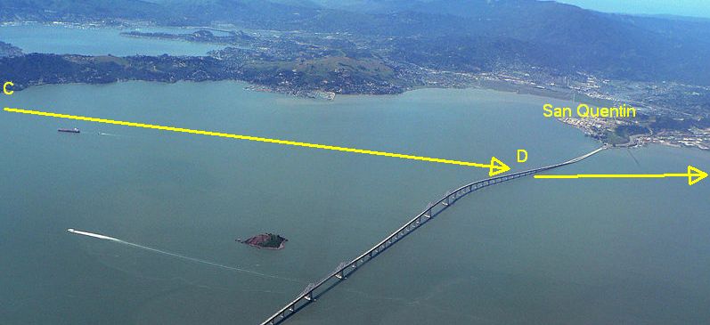
The Golden Gate Ferry comes in and out of this area in a narrow well marked channel. Pilings with Red and Green Markers line the channel. These are large wood pilings with Markers on top. Green Markers will be poles with large green squares on top.They will also have a number. Pilings with Red Markers will have triangular shaped placards on top of them You will be crossing perpendicular over the Ferry (pictured below) route so it's a quick pass but unlike open water the Ferry has no option but to stay in the channel so cross with caution.
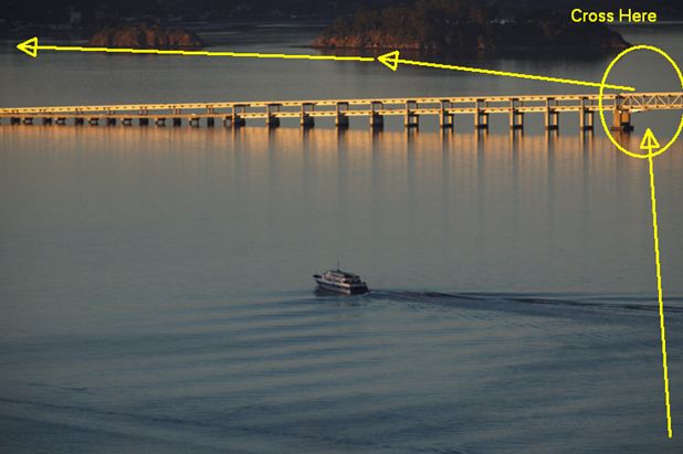
Point D - The water under the bridge can be turbulent. Crossing under the very first set of XXXX markers (pictured) is the safest. As you emerge to the other side head straight for Point E. This will require you to make leftward progress towards the Marin shore
Point E – San Rafael Creek. The entrance to San Rafael Creek is marked by three very large Power Line towers grouped closely together. Head for the middle one. Be careful going to close to the left shore line as it's shallow. You will again see Piling Channel markers with red and green placards as you close in on San Rafael.
Racer Finish – A buoy will be just off the 101 Surf Sports Dock. Pass between the buoy and the dock. Buoy will be on your left side. Non racers please do not cross the finish line.
RED RIGHT RETURN. This is what a boater is thinking as they are coming home to their marina. This means boats will always want RED colored navigational marks on their right hand side when they are coming home and on their left hand side when leaving the marina. Knowing this helps you predict what direction a boat needs to go and stay clear of their traffic areas.
Use the button below to reserve your space now.
Click here to download a MS Word Document of this entire package.